


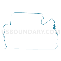
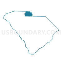
Springfield Voting District, York County, South Carolina
About
Outline

Summary
| Unique Area Identifier | 666983 |
| Name | Springfield Voting District |
| County | York County |
| State | South Carolina |
| Area (square miles) | 2.59 |
| Land Area (square miles) | 2.54 |
| Water Area (square miles) | 0.06 |
| % of Land Area | 97.86 |
| % of Water Area | 2.14 |
| Latitude of the Internal Point | 35.02743120 |
| Longtitude of the Internal Point | -80.90870590 |
Maps

Graphs
Select a template below for downloading or customizing gragh for Springfield Voting District, York County, South Carolina


Neighbors
Neighoring Voting District (by Name) Neighboring Voting District on the Map
- Dobys Bridge Voting District, York County, SC
- Fort Mill No. 1 Voting District, York County, SC
- Fort Mill No. 4 Voting District, York County, SC
- Nation Ford Voting District, York County, SC
- Pleasant Valley Voting District, Lancaster County, SC
- Pleasant Valley No. 2 Voting District, Lancaster County, SC
Top 10 Neighboring County Subdivision (by Population) Neighboring County Subdivision on the Map
Top 10 Neighboring Place (by Population) Neighboring Place on the Map
Top 10 Neighboring Unified School District (by Population) Neighboring Unified School District on the Map
Top 10 Neighboring State Legislative District Lower Chamber (by Population) Neighboring State Legislative District Lower Chamber on the Map
Top 10 Neighboring State Legislative District Upper Chamber (by Population) Neighboring State Legislative District Upper Chamber on the Map
Top 10 Neighboring 111th Congressional District (by Population) Neighboring 111th Congressional District on the Map
Top 10 Neighboring Census Tract (by Population) Neighboring Census Tract on the Map
- Census Tract 112.01, Lancaster County, SC (9,463)
- Census Tract 611.04, York County, SC (3,973)
- Census Tract 611.01, York County, SC (3,895)
- Census Tract 610.08, York County, SC (3,193)